By me
All photos me too, copyrighted
Of all the things I’d learned during the 2020 lockdown, perhaps the most interesting was that to get my weekly aviation fix, I don’t necessarily need… airplanes 🤔. With our Q400s mostly chained to the ground and the C172 enjoying the fine weather down on the coast, it dawned on me that I could use my newfound free time to hop in the car and go visit some of the many abandoned crop dusting airstrips scattered throughout eastern Croatia – quiet and forgotten reminders of a time when this small region all but fed the whole 22 million strong population of former Yugoslavia.
Apart from the obvious Achtung, Skyhawk! nerd factor, the idea was not without a host of other merits: a change of scenery would do me good… as would the fresh countryside air… and knowing the runways’ current states could come in very handy in case of a forced landing en route, being far more preferable than going down into the corn. Win-win really!
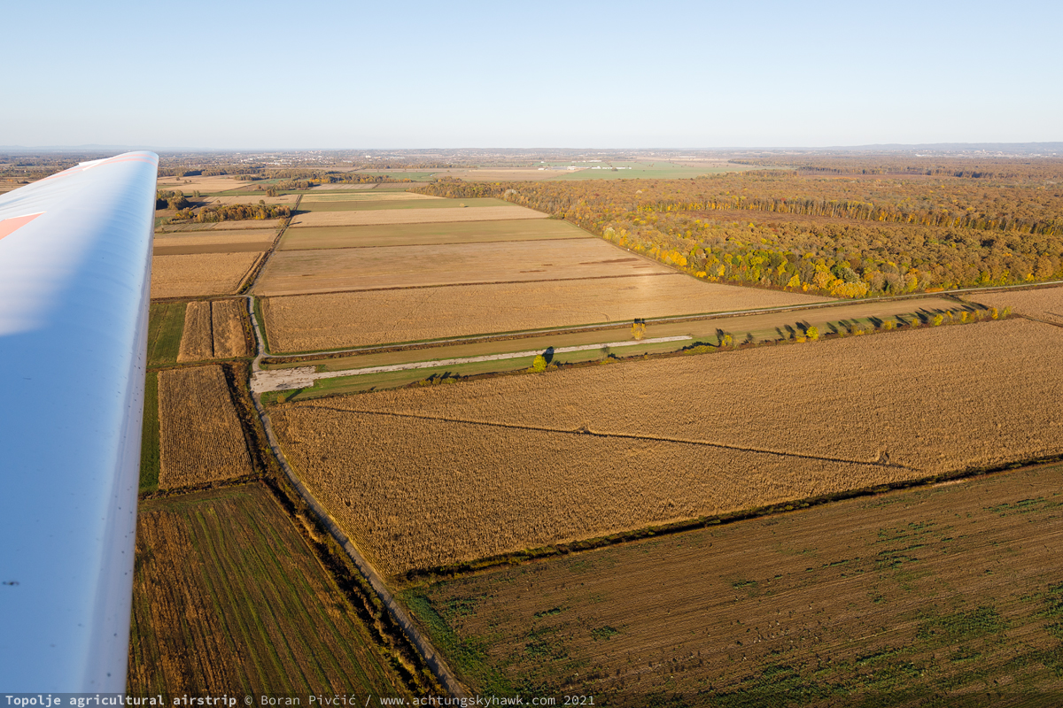
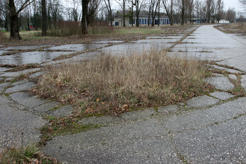
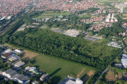
Sneaking a peek at the Topolje strip, one of several located within a stone’s throw from Zagreb
But, as ever so often happens around here, what was supposed to be just a simple road trip to kill the time had inevitably taken on a life of its own – as the cover photo, which features an airplane and not a car, clearly suggests. Bit by bit, the whole thing had evolved into an actual documentary project, which had by the end of 2022 grown to include a sizable collection of photos and videos from a dozen strips – all of which were just begging to be turned into another long-winded article!
Methodology (and madness)
However, this being such a fascinating topic for me, there was a very real chance of going completely overboard with it. The number of strips that survive to this day – as well as their “bland” natures and generally unremarkable individual histories – risk turning any comprehensive list into a dreary quagmire of names, numbers and bullet points, which is not really what this site is about. Thus, to prevent bogging down what could otherwise be an interesting read, I decided straight away to focus solely on the current states of the 12 strips I’d visited (w/ photos obviously), preceded by a short preamble about their raison d’être and a few obligatory Achtung, Skyhawk! factoids.
Because this project was kick-started by sheer boredom, the method that I used to assess the above is, unsurprisingly, fairly unscientific. For the most part, it boiled down to rocking up by car, inspecting the runway on foot and by drone, noting close-in obstacles – and then, situation permitting, driving down the length of it. The reasoning here was that my car weighs roughly what a fully loaded late-model Cessna 172 would weigh, and attempting to hit a realistic landing speed would give me a batter idea of just how (un)usable the runway actually was. Later in 2021, my new motorglider endorsement had opened up a whole new avenue of aerial reconnaissance – and, in the summer of 2022, even the option of making an actual landing. But, for consistency’s sake, the assessments that will be presented here are based on my ground visits only, since they are far more representative and substantial than just casually flying by…
Maize Force
The story of these strips itself starts back in the late 40s with attempts by the Yugoslav government – by then a socialist federal republic – to restart the country’s war-torn agricultural sector. After some brief and unsuccessful flirtation with Soviet-style kolkhoz units – nationalized private land grouped into large collective farms controlled by local municipalities – the state hit upon the idea of instead allotting that land to purpose-made self-contained industrial organizations that would be able to do everything from basic farming to producing and marketing finished goods from the resulting crops. Called poljoprivredno industrijski kombinat (PIK, occasionally IPK) and roughly translated as Combined Agricultural-Industrial Enterprises (or “combines”), their viability hinged on commanding tracts of arable land that were both large enough and contiguous enough to sustain efficient mass production. The only places where there was enough of that to go around, however, were the Croatian regions of Slavonija and Podravina, both taking up the southern end of the very fertile Pannonian Plain. This land was so productive in fact that many combines would eventually reach huge proportions even by the Western standards of the day; the biggest of them all, IPK Osijek (1961-2013), would at its peak control an area of nearly 900 km2 – while the “original gangsta combine”, PIK Belje, grew to encompass 360 km2 in a region that itself barely made it over the 1,000 km2 mark.
These sort of sizes, compounded by an ever-growing number of PIKs and a general increase in demand for foodstuffs, eventually led to a whole new set of operational issues – chief among which was how to best throw a (very) limited amount of machinery at them. Despite the fact that Yugoslavia had started designing its own motorized farming equipment – and producing it on a large scale – already by the mid 60s, the truth of the matter was that relying on surface means alone was simply becoming too impractical, expensive and time-consuming to be viable. Mirroring similar developments elsewhere, the government thus had little choice but call on the power of air power 💪.
The basic idea was simple enough: many large-scale and labor/machine-intensive farming ops could all be done quickly and cheaply by just a handful of specialist airplanes, which could then be easily deployed to wherever the need arose – thus avoiding the need for each PIK to maintain a large, expensive and duplicated equipment pool. All that was necessary for this to take off (heh) was a fleet sufficiently large to make a meaningful operational impact – and a professional authority that could manage it without undue distraction from non-essential tasks. The latter would take the form of twin units called Privredna avijacija (PA, literally Commercial Aviation), the larger being based in the “Slavonian capital” Osijek, and the smaller one in the actual capital Zagreb (plus a tiny semi-independent outfit operating out of Daruvar). Commanding, on average, around 40 airplanes between them at any one time (for a historical total of 74), throughout their lives they would field a pretty eclectic mix of types from both sides of the Iron Curtain, an upshot of non-alligned Yugoslavia’s traditional tactic of playing the East and West against each other for access to its market. PA Osijek would thus end up operating:
- the Antonov An-2 as the dominant type
- the PZL-Mielec M-18 Dromader
- as well as the homegrown Utva U-60AG (a mod of the Cessna 180-lookalike U-60) and the U-65 Privrednik (a purpose-built Pawnee-like design based on the U-60)
PA Zagreb, on the other hand, would become a Vero Beach bastion, with a fleet made up of:
- the Piper PA-24 Pawnee and PA-39 Pawnee Brave as the backbone
- a small number of the Air Tractor AT-400 series
- and a lone Cessna A185F AGcarryall, which I would years later get to fly as 9A-BKS
Nominally under PA Osijek but in practice almost autonomous, PA Daruvar would also march to its own tune, flying exclusively the Cessna A188 as the only operator of the type in the country.
In addition to the “front line” machinery, both Osijek and Zagreb would also operate a number of non-ag types for liaison and training duties, including the Piper PA-18 Super Cub, the PA-23 Apache, Cessna 402 Businessliner – and even a single Let L-200 LIBIS. Interestingly, the service also had a few Agusta-Bell AB.47G helicopters on hand, which would eventually be leased to the Yugoslav Police to form its first air units, kicking off a “Bell connection” that in many places continues to this day…
Cheap strip
With the airplanes sorted out, all that remained were – the runways. And while one may be tempted to ask “just that huh?”, the truth of the matter is that this was actually far simpler to do than it sounds. Since the fleets would normally be based at one or two major airfields near their respective base cities, and then dispatched to wherever needed solely for the duration of the work, the infrastructure necessary to support them out in the field could be as basic as it gets: an open field or a piece of tarmac with sufficient length and bearing strength, and off you go. No hangars, no terminals, no aprons, no facilities, no lighting, no navigation aids… just a turn pad or two, road access, a few trucks for load and fuel and that’s it. Indeed, this was such easy work that a staggering 159 would be built between the mid 60s and 1990, all crammed into an area of just 15,000-odd km2 – only slightly larger than metropolitan Paris, and with its longest axis measuring at just 250 km!

A bit of perspective: the number of fields I’ve visited… and the number of fields that were built (the colors indicate the series of visits: red 1st, yellow 2nd, green 3rd, magenta aerial). Since they were so simple – and took up little physical space – they could be quickly built by the dozens and positioned as close to productive fields as possible in order to cut down on the transit times. Indeed, there are multiple instances of strips being built just kilometers apart – which may sound wasteful, but on the envisaged size and time scale of the operation, actually made a lot of sense in the long term
However, while the PAs were directly owned and managed by the state, the runways themselves would fall under the purview of the individual PIKs, which would build and maintain them according to their own needs and capabilities. Despite this – and the fact that the whole network took the better part of three decades to build – the more permanent strips show a remarkable degree of uniformity to their design, even though there was no single definitive pattern used. While I was misled by initial Google Earth measurements into believing that the surviving paved runways are all 650 x 10 m, a conversation with Mr. Josip Klobučar – who flew for PA Osijek and is the author of the only comprehensive, primary-source book on its history – had revealed that they could be anything from 600 to 700 m in length, and between 8 and 17 m in width.
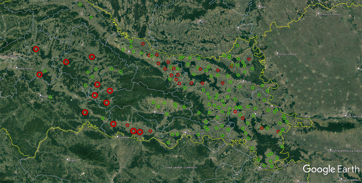
The lopsided distribution of paved/semi-paved (red, 35 in total) and unpaved (green, 124) strips
In fact, the whole system was – whenever possible – scaled to meet the demands of the aircraft that would use it. In the words of Mr. Klobučar, Osijek’s An-2s (the most numerous single type in either PA) were happy with just the most basic grass strip – hence the abundance of these in PA Osijek’s area of operations. These too were up to 700 m in length, though the ample space of the average field allowed them to be significantly wider, up to 30 m.
Dromaders, on the other hand, were a bit more picky; for while they too could happily operate out of grass strips just like the Antonovs, their higher wheel loading was known to damage the runway surface, particularly at soft-turf strips near rivers or lakes (which pretty much means most of Slavonija). Thus, in areas where they tended to operate more frequently, they were accommodated by a string of paved strips, the biggest of which was Mirkovac (top right in the GE screenshot above), which boasted a fetching 700 x 17 m runway with two aprons that allowed for operations of multiple aircraft at once – a setup that Mr. Klobučar referred to as the “most comfortable strip of them all”.
Further west1, the situation was very much the same. Like the M-18s, PA Zagreb’s Pawnee Braves and Air Tractors were happiest operating out of a hard surface, which accounts for the concentration of red circles to the left. I’ve been told that “regular” Pawnees, being lighter, could handle grass a bit better, but even they got concessions on softer ground – particularly at Topolje (featured in the cover photo), whose first half, used for the initial take-off run and landing, was paved, while the remainder was not.
1 while on paper both PAs had their defined areas of responsibility, in the real world this “east-west” divide was not as rigid as it first seems. In conversation with Mr. Klobučar, I came to understand that there was quite a bit of overlap between the two (and a half) PAs, with numerous instances of Osijek-based aircraft operating out of Zagreb and vice versa. Since this was apparently IRL SOP, it could explain the string of paved strips along the border with Bosnia, well within Osijek’s sphere of influence, but apparently frequented most often by Zagreb’s Pawnee Braves and Daruvar’s 188s…
I spy with my little drone eye…
However, even though new strips were being built as late as 1990 (mostly replacements and/or relocation to new sites), the violent dissolution of Yugoslavia in 1991 would bring the whole operation to a screeching halt. While some PIKs did make it through the war and even survive into the 21st century, at the start of hostilities even their most basic operations would be decimated, let alone “luxuries” such as having access to an air force. This had overnight made the vast majority of airstrips pretty much useless, not least of all because a significant portion of the PA fleet would go on to fight in the war – the most famous of which would be the An-2 “boiler bombers” (armed with improvised bombs made out of gas cylinders and boilers, pushed out of the cabin by the crew) and the “close air support” Dromaders and ATs, fitted with rudimentary aiming sights and a full suite of underwing or fuselage stores.
Following the end of hostilities in 1995 and the reintegration of occupied parts of Slavonija in 1998, no fresh need for the majority of these runways had ever emerged. Grass strips would be the first to disappear, blending seamlessly into the landscape – while only a handful of paved runways would be converted to public use, a couple even receiving ICAO location indicators. Eventually even they would be (mostly) abandoned and (completely) forgotten, visited today solely by tractors, teenagers looking for a bit of privacy – and misguided airliner drivers with nothing better to do in their free time…
In order for the results of these efforts to make sense, I’ve decided on the following labeling convention for each strip:
name (w/ Google Maps link) • PIK served • runway direction (magnetic) • dimensions • state when visited
followed up by a short (or not) commentary and a couple of photos. So let us begin!
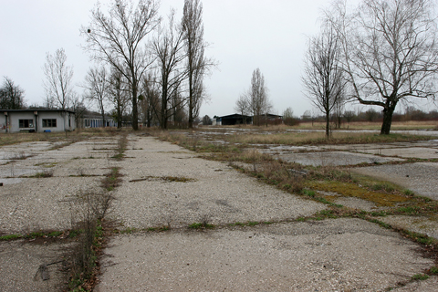
1. Badljevina • PIK Ilova • 291° / 111° • 610 x 8 m • unusable (07 JUL 2020)
Starting the list off with the only strip that was not accessible overland (blocked access routes on all sides), so there’s no useful commentary on its exact state; probably for the best really, since an aerial inspection revealed that it is nowadays used for storing manure. Located within spitting distance of Daruvar town, in its heyday it was probably used mostly by PA Daruvar’s A188s and PA Zargeb’s Pawnee Braves…

Happy to let the drone do the leg work on this one… located at the foot of a range of low wooded hills, Badljevina is definitely in the top three most picturesque strips I’d visited, and is absolutely epic when the low afternoon sun hits just right
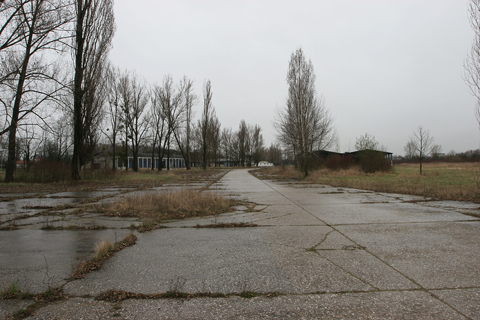
2. Dubovac • PIK Nova Gradiška • 313° / 133° • 700 x 8 m • limited (21 MAY 2020)
One of those strips that were frequented both by Zagreb and Osijek PAs, Dubovac served one of the more productive PIKs of the time – and, incidentally, one of the biggest producers of fruit juice in Yugoslavia (much of which went to export). Though the surface itself is in good condition, there are a number of obstacles all round, most notably a large haystack off the southern runway edge at the 550 m mark (which is consistently there in satellite imagery) and what appears to be a semi-permanent beehive at the eastern end…

Though the angle gives off a strong “middle of nowhere” kind of vibe, the runway is actually located just 1.2 km from the main Ljubljana-Zagreb-Belgrade highway – itself another Yugoslav mega-project that was once known as “The Highway of Brotherhood and Unity”
3. Gaj • PIK Lipik • 260° / 080° • 650 x 10 m • unusable (15 OCT 2021)
A strip I became aware of – to my chagrin – only after reading Mr. Klobučar’s book, despite it being in close proximity to three other runways, and even occasionally visible from my Q400 on arrival into Zagreb. Nowadays a “multipurpose” runway (used for storage of manure AND as a tractor thoroughfare), this is IMO one of the trickier strips to get into even outside of an emergency, partly due to poor traction and braking action from all the mud – and partly due to a number of ill-placed power lines on both approaches…

Hiding in plain sight. This flying visit on 19 JUL 2022 had revealed that not much has changed since I’d been here by car nine months ago…
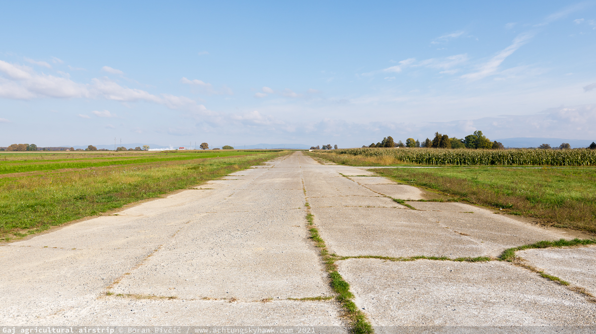
With the fields all around being active farm sites, ground traffic on the strip can be comparatively heavy, which makes it another one of those “later than last ditch” choices…
4. Grabovnica (LDZC) • RWY 01/19 • 650 x 10 m • usable (13 JUN 2021)
Hands down my favorite of all the strips I’d visited – and entirely for romantic and biased reasons. Years and years ago, Čazma became the first runway of its kind that I became aware of – as well as the first one I did actually land a Cessna 172 on, back in 2006 when it was still open for business. “Open”, however, should be taken with a grain of salt; for while it did have a tower (or rather, the skeleton of a tower) and a small support apron, there was never really any permanent presence here; like the others, it was just a basic, spartan stretch of tarmac in the middle of a field. There was once a local flying club tased with keeping it open; but various Balkan reasons (political, financial, societal, interpersonal) eventually forced its closure sometime around the year 2010, with the field disappearing from VFR charts overnight.
Just 45 minutes by car from my house – and 10 minutes by motor glider from Zvekovac (LDZE) – Čazma is on my radar quite often, so I do get many a chance to check on its progress. Even though it is located on the site of a WW2 emergency airstrip (made by the Partisans in 1944 for evacuation of wounded), in its current form it appeared only in 1986, and until the collapse of the PAs was used pretty much only for training and liaison flights – so it is by far and away in the best shape of the lot, and could easily sustain normal ops, let alone emergencies. And while there is a low power line some 150 m in front of the RWY 01 threshold, the only significant issue is mud and dirt on the runway, being regularly used by tractors and harvesters shuttling from one field to the next…

A tight, sloping runway… a beautiful backdrop of low hills… and a ton of historical significance… who wouldn’t want to land here? Indeed, back in September 2006, Čazma was host to one of the biggest GA airshows seen in Croatia since 1991, one last hoorah before it closed for good…

Because of its WW2 history and the fame accorded to anything Partisan-related in post-war Yugoslavia, Čazma sports a very in-your-face hammer & sickle – as well as a dilapidated and sad Lockheed T-33B Shooting Star (more accurately, TV2 Seastar) coded 10250, which had previously been located at Zagreb Intl (ZAG/LDZA/LYZA) in front of the old Viša zrakoplovna škola flight school, where I used to play on it as a kid in the late 80s…
5. Lipik • PIK Lipik • 305° / 125° • 600 x 12 m • unusable (07 JUL 2020)
One of the widest paved runways in the network, Lipik’s proximity to its “host city” – Lipik town itself, visible to the left of shot – meant that it pretty quickly found an alternate use: as a driving school polygon. Even taking into account that driving classes are not that frequent in a town with a population of just 6,200, the strip is nevertheless unusable due to hay and manure mounds halfway along its length, as well as creeping grass (VERY slippery) on its eastern end…

Might as well give it a whirl… driving school was a long time ago!
6. Nova Rača • RWY 05/23 • 630 x 9 m • usable (18 MAY 2020)
By contrast, here’s one of the most isolated strips of them all – a solid 15 km in any direction from anything else; not much in absolute terms, but quite a lot given the whole network of 159 airfields spans just 250 km. Second only to Čazma in the quality and usability of its surface, back in 2020 it was even on track to be put back into commission by a local flying club – though things appear to have stalled out, since it was slated to open in the summer of 2021, while an overflight on 17 JUL 2021 revealed no progress whatsoever. Here’s hoping to 2023!

Showing a young colleague some of the area’s interesting sights in the hope of enticing more people to indulge in aero-obscurism!
UPDATE (11 JUN 2025): “hoping to 2023” was a bust, best I can give you is 2025. Having popped round there for the first time in years, there were indeed a number of changes, as seen below…
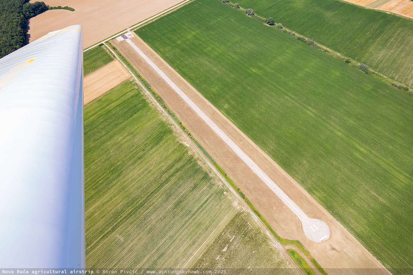
Fresh photo reconnaissance. The biggest difference are (obviously) the new runway markings; more subtle stuff though includes fresh paving of the RWY 05 displaced threshold, patched up holes all along the runway – and, critically, the removal of the entire offending tree line next to the RWY 05 end
7. Stara Subocka • PIK Nova Gradiška • 027° / 207° • 620 x 12 m • limited (21 MAY 2020)
The westernmost of seven strips belonging to PIK Nova Gradiška, Stara Subocka is also the most difficult to reach by land: three kilometers of unpaved tractor trails that a hardly a fun drive in a 2WD city car. With a pretty generous runway both in terms of width and length, it is also surprisingly devoid of obstacles in the approach paths (which in years past lent it well to practice engine-out approaches) – but is let down by the state of the surface itself. While not as bad as some I’d visited, it is definitely far from ideal and thus viable solely in a more serious and/or time-critical emergency…
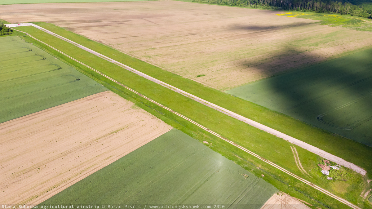
Out in the the fields – quite literally

There’s your symptom. While it doesn’t look it on the photo, the surface makes for quite a bumpy ride for most of the runway length, though any self-respecting GA aircraft could handle it – at least once, when it is most necessary
8. Štakorovec • PIK Vrbovec • 335° / 155° • 650 x 8 m • limited (22 OCT 2020)
A strip that hits close to home – mostly because it is close, located on the northeastern edge of the Zagreb metropolitan area. Another late 80s runway, it sits right under the approach path to Zagreb’s RWY 22 (and even slightly within the Zagreb CTR), which again affords numerous opportunities to check on its state. Since it fits rather snugly between two busy plots of land, its usability rather depends on how high the corn is at any given moment; the surface itself is in an OK state, though, like Čazma, it is covered in a fair amount of mud all year round…

Is this what it is meant by “seasonal availability”?

Even without the corn, the shrubbery along the runway edges makes landing a low-wing aircraft here a hugely unappealing prospect… particularly a motorglider
9. Štivica • PIK Nova Gradiška • 006° / 186° • 650 x 12 m • usable (21 MAY 2020)
An incredibly picturesque runway in the middle of nowhere (“twinned” with Vrbje some 5 km to the west), it had been perfectly usable on my last visit, and looks like it could handle even considerably heavier stuff than the 172. The only thing to be mindful of is the shrubbery on the southern end, which IRL is considerably taller than it appears here…

Hard to beat both the view and the convenient road access
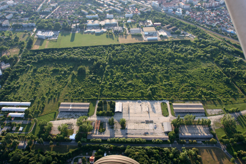
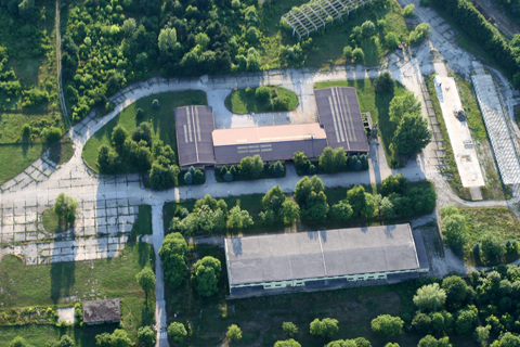
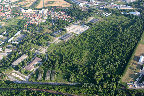
10. Topolje • Agroposavina • 112° / 292° • 600 x 12 m • unusable (12 OCT 2021)
The strip featured in the cover photo – and pretty much the biggest oddball in the entire collection 🤔. While the majority of runways in the network were either all-grass or completely paved, 11 were made with an interesting soft-hard surface mix. The proportions varied between individual strips, but usually entailed 300 m of asphalt or concrete (160 to 460 being the extremes), with grass making up the rest until the usual 600-700 m total length. Interestingly, all 11 were quite wide, with a roughly even spread of 12, 13, 14 and 15 m between them.
Located just 30 km from Zagreb, the site chosen for Topolje was within easy reach of the Zagreb PA; however, its close proximity to the Sava River – just 1.5 km as the crow flies – meant that the water table would be a big issue. This in turn posed problems for the Pawnees, whose comparatively high wing loading and long take-off runs were guaranteed to make a mess of things whenever the ground got even a wee bit soggy.
The need to accommodate the most numerous type in PA Zagreb’s inventory – and spend as little money as possible doing it – let to the brainwave of copying the same “composite runway” idea as used in similar terrain further east. While shaving off the expense of laying down several hundred meters of pavement more, this setup would still allow a loaded Pawnee to accelerate with as little rolling resistance as possible, transiting onto grass only after enough lift had been generated to measurably reduce the airplane’s load on the surface. Similarly, the PA-25’s draggy airframe meant the paved bit would be more than sufficient to come to a full stop when landing, adding yet another round of arguments against paving the entire length.
Opened in the mid 80s, Topolje would thus sport a pretty standard 300 m asphalt / 300 m grass combo, with a pavement width of 12 m. However, whether its design checked out in practice is hard to assess – if anything for the very short amount of time the runway was used at all. Today though, you’d be hard pressed to call it even partly usable; for while the pavement itself is in passable condition, there’s a buzz-killing tree right on the runway edge at the 250 meter mark, which, combined with soft ground and lots of shrubbery all round, doesn’t make for a particularly attractive landing ground…

As was the case with Gaj, I was completely oblivious of Topolje’s existence until very recently, despite its proximity to Zagreb; however, unlike Gaj, I did manage to first sight it while overflying the area in the Q400, so I got that going for me, which is nice
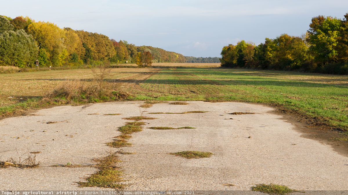
The end of the line: rough by 2021 standards, but probably far smoother back in its glory days
11. Vrbje • PIK Nova Gradiška • 093° / 273° • 600 x 12 m • usable (21 MAY 2020)
The aforementioned twin to Štivica, Vrbje is a tiny bit smaller – but is equally usable, despite being significantly bumpier. Still, when passing by with a wonky engine about to die, it’s as welcoming as Frankfurt!

It really is hard to fault the scenery around here… all that is missing is the roar of a big nine-cyl radial…
BONUS: Blagorodovac (LDVD) • PIK Ilova • RWY 02/20 • 600 x 8 m • usable (22 JUL 2022)
And finally, a very special treat – though I suspect more for myself than the reader 🤔: a visit to the Blagorodovac strip near Daruvar. At first, it’s hard to see what all the special fuss is about: the runway is pretty humdrum (albeit a bit tight laterally)… there’s nothing special in terms of facilities… and it has a few standard-issue post-war close-in obstacles on both approaches. However, what it lacks in looks it more than makes up with substance, as:
- it is home to the last airworthy survivor of the original PA fleet
- it is still in sporadic use today, though closed to the public
- and I was going to get the chance to actually land there (again)!
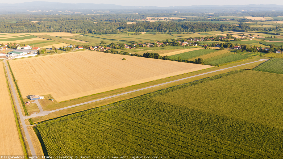
More pretty landscapes, made all the better by huge tracts of peaceful private land all round. The hangar and fuel pump are modern, post-war additions

A village on one end, trees on the other, and a power line to the right… should be an interesting one!
But, to fully set the scene for that last one, we first need to back up a bit. As mentioned in the preamble, the Daruvar area was unique in having its own semi-independent branch of PA, which was Croatia’s sole operator of “The Poor Man’s P-51”: the Cessna 1882. It’s four-strong fleet, delivered in two batches on opposing sides of the mid 70s, included:
- YU-BIE | A188B AGwagon | s/n 188-01073 | mfd. 1973
- YU-BIF | A188B AGtruck | s/n 188-01091 | mfd. 1973
- YU-BKP | A188B AGtruck | s/n 188-02875T | mfd. 1977
- YU-BLA | A188B AGtruck | s/n 188-02943 | mfd. 1977
Fitting snugly between the regular Pawnee and the Dromader and AT, the 188’s combination of capacity and operating costs lent it particularly well to use in the Daruvar area, where the low density of strips – the second lowest after Zagreb – meant that transits to the working areas were necessarily longer, making bigger and thirstier machines unviably uneconomical.
2 a small pause for a big rant vis-a-vis the complicated designation system used for the 188: prefix, suffix, serial number, even the name itself – it all matters in trying to decipher which version is which. In the beginning, there were just two:
- the basic 188 AGwagon 230, sporting a 230 HP Continental O-470-R engine, a 760 l hopper and a 1,720 kg MTOM
- and the more capable A188 AGwagon 300, with a 300 HP IO-540-D, the same hopper and a 1,815 kg MTOM
As they entered service, inevitable small issues began to crop up, which Cessna addressed with the improved 188A and A188A. The mess, however, would start with the 188B AGpickup which, apart from more tweaks, differed only in the use of the O-470-S engine, which had different piston rings and modified piston cooling. Meanwhile, the A188B AGwagon would feature just incremental improvements with no changes to the engine itself. The main troublemaker though would be the A188B AGtruck, which came to denote models fitted with an enlarged 1,060 l hopper. If that was not enough, A188s of all versions that were cleared for a MTOM od 1,905 kg can be distinguished by the suffix T at the end of their serial number (like BKP). And finally, there was the T188C AGhusky, essentially an AGtruck fitted with a turbocharged TSIO-520-T developing 310 HP and an MTOM increase to 1,995 kg.
Like many other PA machines, come 1991 the three remaining A188s (BIF having been lost to fire in 1976) would be drafted into the war effort, following which only BKP would return back to civilian life3. With the PAs dead and buried, it would join the ranks of Poljodar Tim, a private agricultural company that also became the owner of the Blagrodovac runway itself. And while it was far from the only “returning soldier” to continue flying beyond the 90s, as the years went on many of them would either be sold or run out of service life, steadily dwindling away until, by the mid 2010s, only BKP remained…
3 while whole volumes could be written about the wartime and post-war adventures of various PA aircraft, I opted to cover the period only hastily and proceed to the here now by the most direct route possible. Untangling any part of the 1991-2001 period goes way beyond the scope of this work – and as a person who has lived through that time, it is my policy to steer well clear of it. Suffice to say that both BIE and BLA had also survived the war

King of The Hill – literally, since the modern apron at Blagorodovac is the highest point of the entire field

Face Off. Even though it was a scorching hot day – and any work apart from breathing was a whole labor in itself – we just had to push the Falke into position for this shot. Worth it!

An old shot from Lučko, but very fitting: The Last of the Mohicans
The mid 2010s would also signal a change of pace for the strip itself. Despite being privately owned and used solely for the purposes of Poljodar Tim, it had for many years been registered as a public airfield (with ICAO code LDVD), which, in practice, allowed for limited public use such as touch-and-goes – the exact method by which I had first visited back in 2010, halfway into a 300 mile navigation flight with the trusty C172. In 2014 however, it would be re-classified as a “registered area for landing and take-off” – in effect taking it off the grid and charts, and limiting its use solely to BKP and Poljodar Tim’s other aircraft, Reims FR172J Rocket 9A-DAF.
Since forgotten and obscure airfields like these hold a particular allure for me, my inner aero-obscurist/child was unsurprisingly through the roof when told in 2022 that it was actually possible to arrange a one-time full stop landing there. Despite having already visited in passing, it still took a minute for my enthusiasm to subside enough for me to start working on the logistics of said landing – particularly since the aircraft I’d use, the aforementioned and aforepictured Falke, was hardly the ideal backwoods STOL bruiser.
Because the runway was still being maintained and in use (albeit sporadically), I could be reasonably sure that I would be able to use the airplane again after landing – so my planning quickly focused on the specifics of the Falke’s landing gear. First, there was the question of shock absorption; while the C model Falke does have a shock absorber on the main wheel, the unit is essentially just a simple rubber spring – which means its capacity to soak up larger bumps is limited, so it was entirely possible for the landing roll to turn into an adventure in low speed hopping on the edge of a stall. Then there was the width issue; an 8 m runway coupled with the 6.5 m span of the Falke’s outriggers left preciously little space to play with on the sides. And while the turf on both edges of the runway was flat and clean – really no worse than the average grass strip – hitting the centerline exactly was definitely the most preferable course of action.
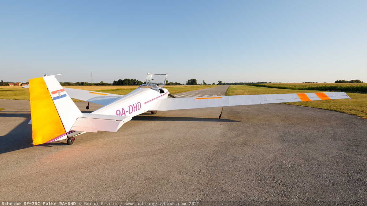
Perspective. Even though the runway is wide enough to accommodate a host of GA types, the Falke’s 15.3 m wingspan gives a pretty convincing illusion of extreme tightness
Then there was the weather. The difficulties in successfully bringing together severe CAVOK, the rest requirements of my day job, DHD’s upcoming heavy maintenance, and the airstrip owner’s will to indulge me, meant that I was left with just a very small window of opportunity in which to do the flight. Since the patron saint of aviation – Murphy – was diligently overseeing proceedings, that window inevitably fell right in the middle of a heatwave and on the hottest day of the year, when temperatures even outside the cities peaked at 38° C. And while 20 years of general aviation had steeled me for the physiological torture of a tight cockpit in summer, what was a worry was DHD’s wheezy 60 HP engine, which would probably be developing closer to 50 in the heat. With two of us and three hours worth of fuel on board, we’d be leaning on the MTOM like drunks on a fence, so climb performance was an area I’d need to consider well in advance.
To reconcile these issues with my desire to avoid appearing in any accident inquiries, I opted for a pretty conservative strategy. It would start out with a slow inspection pass down RWY 20, followed by a base turn into a practice approach for RWY 02, chosen for landing due to its slight upslope and because it would keep the sun behind out backs. Planned from the outset to end in a go around at low altitude, it would allow me to better survey the position of obstacles in the approach path, judge visual cues for landing, and then see just how much (little?) climb performance we actually had (in case an actual go around became necessary). Following a second base turn, I’d make a noisy run back down RWY 20 (as noisy as it can be in Falke), hoping to scare away any wildlife that hadn’t already died laughing at just how pathetic the whole spectacle actually was. Finally, base turn #3 would bring us in for the actual landing.
Another measure I felt could come in handy was coming in with a slightly higher speed, 110 km/h vs the 100 that would be sufficient for our mass. The idea here was to carry some extra energy in case we have to go around at the very last moment, since I would then need some time to switch my hand from the spoiler handle to the throttle, during which I could use up that extra 10 km/h in holding off the touchdown. The trade-off was the potential for a long float, as well as a bounce off the bumpy surface immediately after touchdown (which eventually did happen); the former I judged to be acceptable since I had more than enough runway to come to a full stop even if I landed beyond the 200 m mark, and could also extend the spoilers fully to almost instantly settle down onto the runway. The one choice that didn’t age so well was my intention to land very slightly off the centerline, in order to have an extra margin to the right-hand runway edge in case we bounce and the day’s left crosswind blows us off to the side. In the end I landed a bit too far left for my taste (but still within the confines of the runway), since I had misjudged the strength of the crosswind.
And for how it all actually looked like, here are two handy vids – the first by myself and the second by my passenger, uploaded with his kind permission!
Take-off, on the other hand, was as straightforward as it can be. While the 60 HP Falke does struggle to climb anytime the air density drops even slightly, it glider DNA means it has no trouble whatsoever in leaping off the runway after just a several dozen meters. Even though we were using RWY 20 for departure so we could take advantage of its downslope, we had left the ground in a surprisingly short 250 m, and by the time we hit the 500 mark were already traveling at a satisfying 110 km/h. Of course, there’s a vid of that as well, with a bonus touch & go on RWY 20 in order to log landings on both ends (#nerdlife)…
Updates:
Sources:
- Privredna avijacija Osijek, by Josip Klobučar (printed book)
- 80s Yugoslav and 90s Croatian registration database, by Vojislav Jereb
- Croatian Civil Aviation Authority’s airport registry


airfield history")


airfield")

airfield, Zagreb")