By Boran Pivčić
All photos author, with assistance from Google Earth
In a slight departure from the usual General Aviation theme, I thought I’d try my hand at some aviation history for a change. Trying to avoid the usual bland history lessons, I chose instead to quickly profile the first “real” airport in Zagreb – Borongaj airfield – and spice it up with some pictures of what’s left of it today (which isn’t much). I had wanted to include some historical imagery, but that either doesn’t exist in the form that I need, or is copyrighted… so you’ll have to extrapolate from my contemporary photos :).
1. Beginnings:
Though not the first airfield in town, Borongaj airfield – located in the Borongaj district to the (then) east of town – was the first purpose-built airport in Zagreb, that is, the first airport meant to serve passengers and what was then emerging to be “scheduled air services” (the first airfield, built in 1910. in Črnomerec on the opposite side of the city, was deemed inadequate and was – as far as I’ve been able to dig up – closed soon afterward).
Opened in 1926., little exact information remains about Borongaj’s specifics. But eyeballing from its heyday in the early 40s, the airport had a single grass runway of a maximum 800 meters in length, stretching on a heading of approximately 020-200 degrees – almost right into the bora, the prevailing wind in Zagreb (which leads to believe that RWY 02 was in use most of the time). Facilities were apparently rather minimal, but enough to open the first scheduled service to Belgrade, Serbia, later the same year using a Potez 25.

Apart from a visit by Charles Lindbergh after his transatlantic crossing in 1927., the airport remained unremarkable throughout the 30s. More services were added, including those to Dubrovnik and Split (Croatia), Ljubljana (Slovenia), Sarajevo (Bosnia), as well as international destinations such as Graz, Klagenfurt and Vienna in Austria, Prague in today’s Czech Republic, Budapest in Hungary and Milan and Trieste in Italy. Apart from the mentioned Potez 25, little information remains about the types operated out of the field.
Undated photograph from Borongaj’s past, showing some hangars at the field’s southern end
2. World War II:
As with many airfields in Europe, Borongaj’s history would shift into high gear during WW2. Following a spirited, but futile two week resistance, Yugoslavia fell to German and Hungarian forces in April 1941 – though not before making aviation headlines by being the only time in history that Messerschmitt Bf.109s faced Bf.109s in combat, when pilots of the Royal Yugoslav Airforce engaged the Luftwaffe with aircraft bought in 1937-8 (in exchange for strategic resources like metals). The occupation of Croatia – and its subsequent re-emergence as the Independent State of Croatia – effectively meant the end of Borongaj as a civil airfield, though it would prove to be a major influence on the birth of local aviation as we know it today.
Borongaj’s major role now became that of a military airbase, housing some of aircraft of the Ustaška Eskadrila, a squadron named after the nationalist Ustaše movement that controlled the country at the time. In addition to Borongaj, the Wermarcht and the Ustaše developed another airfield, an aerodrome we all know and love today: Lučko :). A larger airport developed just before the war in the late 30s (1937 I think, but don’t quote me on that), Lučko was intended to be able to support newer passenger aircraft up to a weight of 15 tons (meaning some pretty large stuff back then). During occupation, it gained a paved runway for all-weather military operations, the remains of which can still be seen at the field today – even though the actual runway had been shifted about 500 meters to the south decades ago.
In addition to these two existing fields, in 1943. the Wermarcht also built a completely new paved airfield to the south-east of town, what would eventually become – Pleso. Today the country’s main international gateway, Pleso has an interesting anecdote connected with it. Those familiar with the airport of today know of the problems its dense and long-lasting winter fogs – with visibilities not rising above 100 meters for weeks on end – cause to flight operations (indeed, the reason why Pleso was one of the first – if not the first – airport in this part of Europe to introduce a CAT IIIb ILS system for sub-50 meter visibilities). In a testament to German engineering, the WW2 airfield was built in this location specifically to hide it in the fog from Allied bombers… and 65 years on, it’s still regularly hidden :).
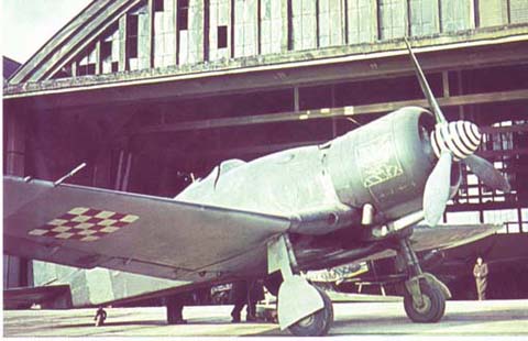
Equipped with a wild mix of Axis types, the main offensive fleet of the Ustaška Eskadrila consisted of Fiat G.50s, Messerschmitt Bf.109Fs and Dornier Do-17 light bombers, supplemented by various liason, communication and transport aircraft of all makes and models – French, Italian, Hungarian, Polish, German, you name it. They were split between the three bases, with – as far as I’ve been able to piece together – Bf.109s and Do-17s based at Lučko and G.50s, with the odd 109, based at Borongaj.
By 1944. and the Allied advance through Italy, these airfields were slowly coming into range of Allied bombers, including fighter-bombers of the Yugoslav Partisans (who, starting as a guerrilla force in 1941., grew into a regular army by the end of the war). Needless to say Borongaj – and a rail yard at its northern end – were extensively bombed, evidence of which can still be seen at the field today (even more so, WW2 bombs are dug up every now and then in that area, now mostly residential).
3. WW2 to the 21st century:
In the immediate aftermath of the war, Borongaj increasingly lost its importance as an airbase. The more modern, better equipped and larger Lučko and Pleso were sufficient for both military and – soon to be restarted – civil needs, leaving Borongaj redundant. Soon afterward, the airbase was closed, the runway left to overgrow and what was left of the facilities was converted to an army base and barracks. Interestingly enough, despite the barracks growing into one of the largest in the area – where many young men, including my dad, served their military service – and expanding into a large and elaborate compound, the area around the former runway, as well as the taxiways and aprons, remained mostly untouched.
4. Borongaj today:
About 2-3 years ago, the military decided to leave the Borongaj complex for a better and more suitable location – and given that the rate of Zagreb’s expansion meant that they were now in the middle of a residential district, I can hardly blame them. Rather than level and rezone the massively expensive and vast complex, it was given to the city to turn into an über-campus, able to accomodate all of Zagreb’s scattered universities and dormitories (the total number of which is about 20). Several buildings were being renovated even as the military was moving out, so it wasn’t uncommon to drive to classes past tanks, anti-aircraft artillery and howitzers :).
The success of the project aside (only two universities have so far moved in, including mine), this opened up the possibility of finally exploring what was left of the airfield in peace, without the military police breathing down my neck. The area available is large, since the four-five university buildings occupy around a mere 10% of the entire complex away from the actual field. So, on an oddly suitable gloomy and rainy day, I set out to see what’s what…
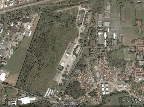
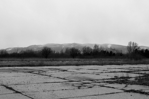
As you can see from the photo, the runway was to the left of the complex. Long overgrown, it is now a miniature forest, making it nigh impossible to actually find any traces of where it began and ended. There are a number of buildings still standing, though some of the more contemporary ones – built during the 60s and later – are being torn down.


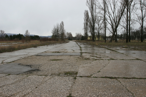
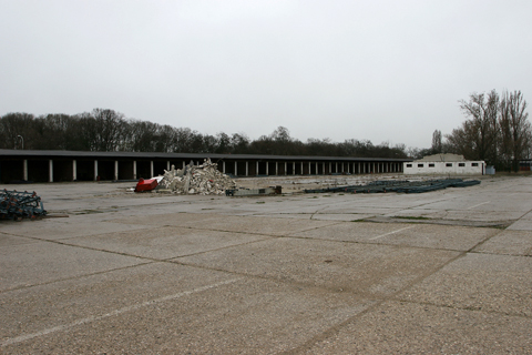
As you can see, the field is not in the best of shapes, but it had been neglected for several decades. Upon closer inspection, most, if not all, of the buildings here were meant for vehicles – garages with mechanic pits and signs like “Vehicle Depot #2” being the most obvious signs – which indicates that the field was periodically used right up until the military moved out. The state of the pavement was probably considered a non-issue to tough military vehicles, so was left to fall into disrepair.

Given that it was a rather cold and rainy day (and I was without a jacket in March), I didn’t spend much time outdoors, instead choosing to look around some of the open buildings (mostly empty. I won’t post any photos since there’s not much to see and they wouldn’t be aviation-related anyway). Unfortunately, I only found out several days later that the northern hangars were indeed WW2 vintage and that I had wrongly dismissed them as something more modern – so I didn’t go and photograph them (an additional issue was that there were some MP cars packed nearby, so I didn’t want to push my luck 🙂 ).
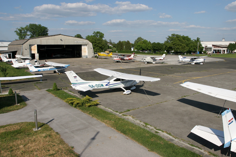
Future plans for the airfield are unknown, but given the university’s current rate of expansion, it’ll be safe for a good 10 years :). Hopefully, somebody at some point will place it on a protected monument list, as it is a large open area of prime real estate – very tempting for the increasingly crowded city (witness Tempelhof in Berlin). One can only fantasize of it being turned into an active airfield, where you can park your generic Skyhawk on the same spot once occupied by a Messerschmitt :)…

Excellent stuff, didn’t know any of that although I live in Zagreb. Thanks a bunch!
Below is a Dropbox link to download the Google / Amazon Kindle versions of the eBook I wrote about my grandfather’s WWII and post war service. He was taken to Agram-Stadt and interrogated by the Gestapo on 30 May 1944 after his B-24 Liberator shot down near Križevci; see narrative starting on page 50 of the PDF:
https://www.dropbox.com/s/5t5lmp48xk4b2uh/MorrisseyFlightTrainingB24LuftStalagMuseumAmazonJanuary2019Revision1.pdf?dl=0
Best,
Jeffrey